Note: Hi, guys! Publishing practice questionaires WITH NO ANSWER KEYS at the moment. Hopefully, this would be beneficial for all the takers of the Geologist Licensure Exam this year. Good luck and share it as much as you want. Regards!

Applied Geology Mock Exam
Field Mapping - Structural Geology
1. Which of the following is/are TRUE about the relationship between the dip of a plane and topography?
a. The outcrop traces of real horizontal planes exactly follow the topographic contours b. With the dip direction in the upstream direction, the pattern made by the traces of the structural planes is progressively modified into a blunter V pointing upstream c. In the of a 90◦ dip, the outcrop traces are straight and parallel to the strike direction, regardless of topographic detail
d. If the dip is less than the valley gradient, but still in a downstream direction, the pattern will V downstream
e. None of the above
2. A concentric series of closed contours with hachure marks on the downhill side represents a __________.
a. ground subsidence
b. closed depression
c. underground caverns
d. hums
e. none of the above
3. How large a sheet of paper is required to produce a 1:5,000 map of a structure whose dimensions are 1km x 1 km?
a. 20 cm
b. 200 cm
c. 10 cm
d. 15 cm
e. none of the above
4. The Every point on a contour line is of the same exact elevation following statements are TRUE about contour lines except:
a. Contour lines always close to form an irregular circle
b. Every point on a contour line is of the same exact elevation
c. Steep slopes are shown by closely spaced contours, while gentle slopes are relatively wider-spaced
d. Contour lines never cross
e. None of the above
5. If adjacent rock units have attitudes parallel to one another, and there is no evidence of erosion on the contact, then the contact is:
a. conformable contact
b. paraconformity
c. disconformity
d. nonconformity
e. no conclusion can be drawn
6. The difference in elevation between two points on a topographic map is called:
a. Bench marks
b. gradient
c. relief
d. datum
e. none of the above
7. A topographic profile requiring vertical exaggeration of 20x would require a vertical scale of ____________, provided that the given map scale is 1:100,000.
a. 1:2,500
b. 1:25,000
c. 1:10:000
d. 1:5,000
e. None of the above
8. When lithologic contacts that dip downstream encounter a dry stream channel, they would form a “V” that points to the:
a. Downstream direction
b. Upstream direction
c. Direction directed towards the face bounding the stream
d. A or c
e. B or c
9. The representative fraction for a map is 1:8,000. At this scale, how long is a scale bar that represents 1 km?
a. 0.125 m
b. 1.25 m
c. 0.250 m
d. 2.5 meters
e. none of the above
10. The scale of the map is 1:8,000. At his scale, how long is a scale bar that represents 1 kilometer?
a. 7.5 cm
b. 25 cm
c. 12.5 cm
d. 10 cm
e. none of the above
11. The distance between two islands on a given map is 10 cm. In reality, these islands are 1 km apart, what is the representative fraction that describes the scale of the map?
a. 1:1,000
b. 1:10,000
c. 1:100,000
d. 1:100
e. none of the above
12. What is the width in kilometers of a single time zone at a latitude 40o? (Note: At 1o latitude=111 km
a. 1500 km
b. 1300 km
c. 1275 km
d. 1400 km.
e. none of the above
13. Suppose that a vertical slope faces due north and exposes a sandstone bed with an apparent dip of 40o, N90oW. Near the said slope, the bed can be seen to strike N258E. What is the true dip?
a. 50o
b. 60o
c. 43o
d. 33o
e. 53o
For questions no. 14-15, refer to the following diagram (The north is located at the left side of the figure):
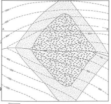
14. The orientation of the beds likely defines a:
a. syncline
b. antiform
c. monocline
d. symmetrical fold
e. none of the above
15. The strike of the bed is:
a. due north
b. due west
c. due east
d. northwest
e. none of the above
For questions 16 to 18, refer to the following diagram:
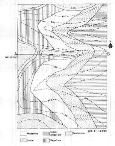
16. Using relative dating, how many geologic events are depicted in the diagram ?
a. Five
b. six
c. seven
d. eight
e. none of the above
17. The mudstone strikes roughly towards the:
a. North
b. west
c. northwest
d. northeast
e. none of the above
18. The oolitic limestone likely dips towards the?
a. north
b. south
c. east
d. west
e. no conclusion can be drawn
For questions 19-25, refer to the following figure
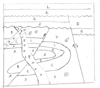
The following are events (in no particular order) depicted in the given figure. Arrange the said events from oldest to youngest and answer the following questions
A. Intrusion of E
B. Deposition of A
C. Deposition of L
D. 1st unconformity
E. Deposition of B
F. Deposition of I
G. 2nd Unconformity
H. Deposition of C
I. Folding
J. Deposition of D
K. Normal faulting (2nd faulting event)
L. Deposition of G
M. Reverse faulting (1st faulting event)
N. Deposition of K
O. Intrusion of F
19. The 1st event is:
a. A
b. L
c. M
d. J
e. O
20. The 7th event is:
a. K
b. O
c. A
d. M
e. L
21. The 9th event is:
a. D
b. O
c. L
d. F
e. K
22. The 15th event is:
a. N
b. G
c. C
d. F
e. K
23. The 4th event is:
a. I
b. M
c. J
d. A
e. H
24. The 11th event is:
a. K
b. F
c. G
d. L
e. D
25. (BONUS) What is the 2nd to the last event?
a. E
b. N
c. L
d. C
e. G
No comments:
Post a Comment